
Walking Kumano Kodo: The Imperial Route
Letters from Japan, April 2026: back to Kumano Kodo, the Nakahechi Route, eight years later.

Good afternoon,
Tokyo is slowly coming out of another short but always delightful sakura season. The green leaves are already taking over the cherry trees, pushing their way through the blossoms, which have begun falling en masse, bringing the spectacle down to the sidewalks.
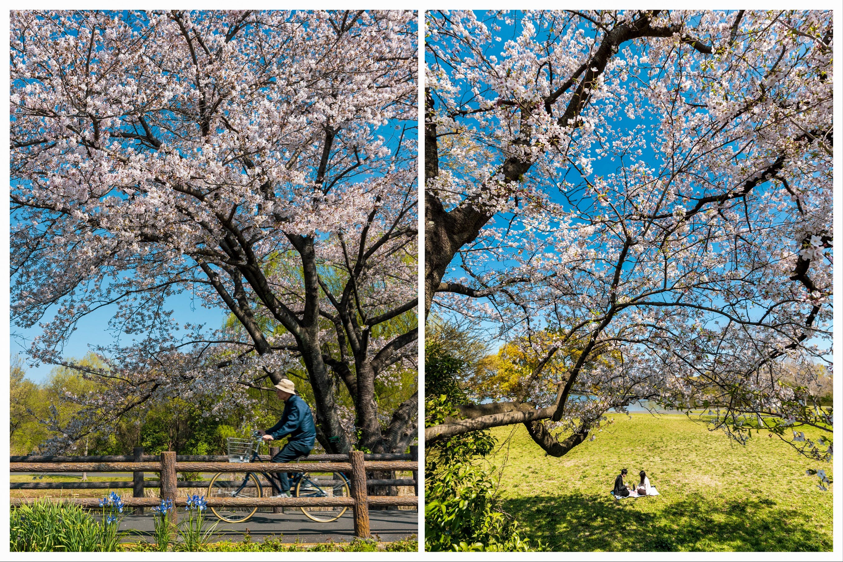
The sakura season, once again, brought many rainy days. It also felt a little less vivid, yet more chaotic this year. But I am grateful for the two full sunny days the Tokyo skies blessed us with, right at the tail end of the peak bloom, and on the weekend. What more could we ask for?
We are now in that sweet spot between seasons - air conditioners off, winter coats almost stored away, and the ever-present breeze switching between a wintry chill and that warm wash over your face.
The mountains are also warming up, with the snow getting a bit slushier each day, before the greenery and then the summer flowers take over.
The peak hiking season should already be underway in the southernmost regions, like Yakushima, with mainland Kyushu and its ever-gorgeous Kuju Mountains soon to follow. It is, however, still too early for the Japanese Alps, and of course, Hokkaido, where you can count on sakura well into May, and should not be surprised to encounter some snow on its mountains in July.
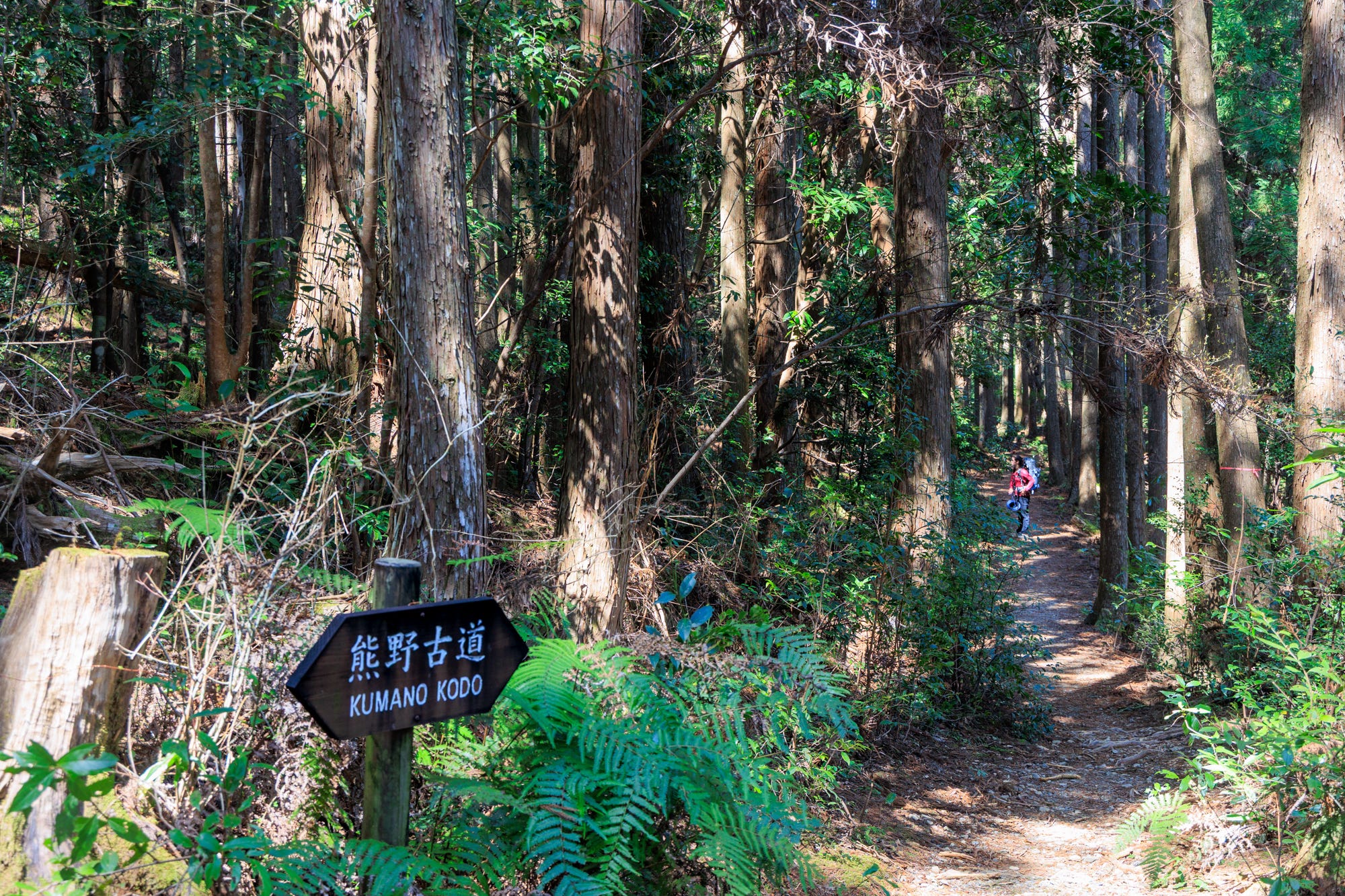
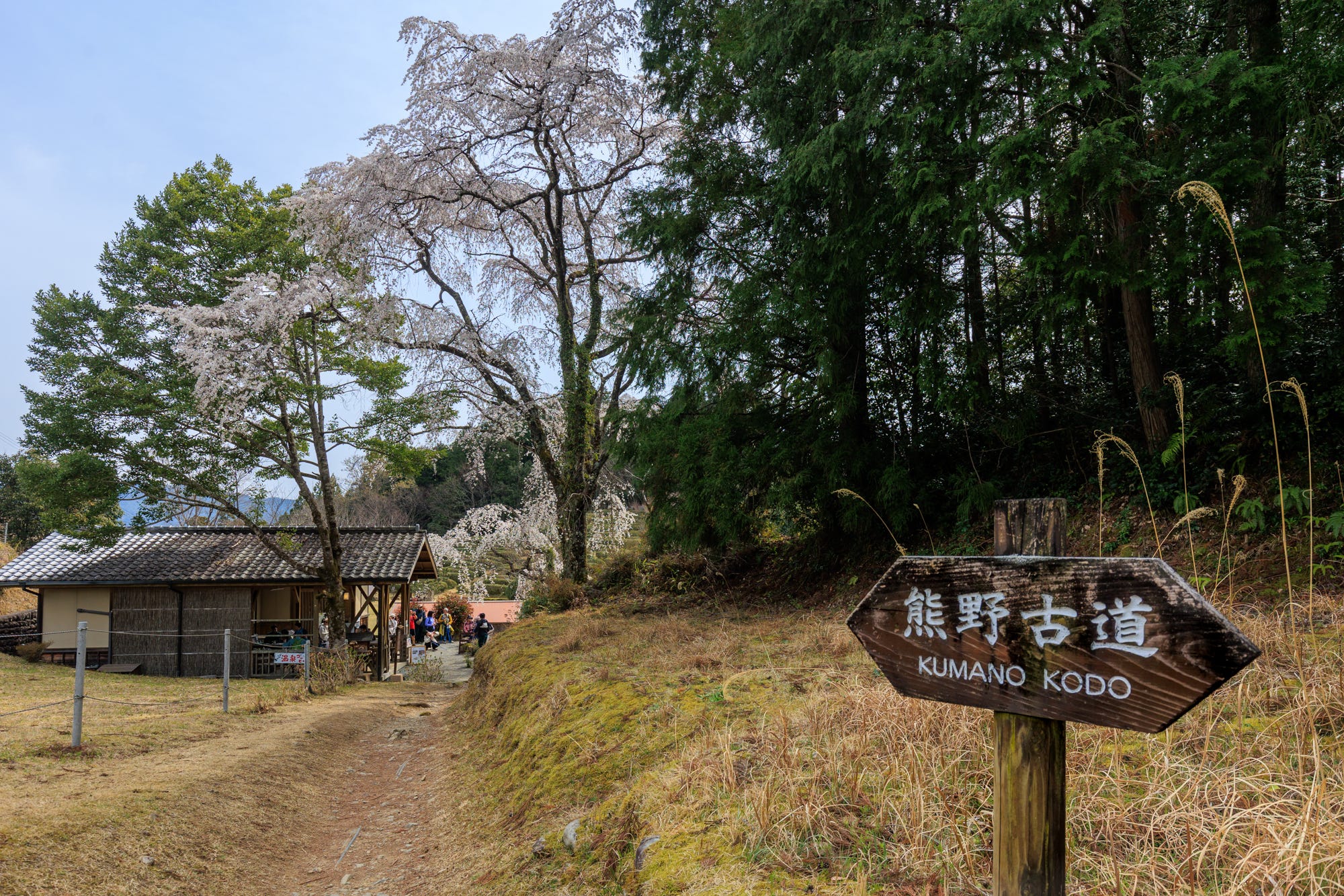
But in this land of mountains, known for their relatively modest height, there are also many trails that are not bound by the seasons and can be hiked year-round. And this month, I come bearing news from one of them: the dearly beloved Kumano Kodo, and more specifically, its Nakahechi Route, once the favored path of the imperial family for their pilgrimage from Kyoto to the sacred shrines of Kumano.1
The Nakahechi pilgrimage route, which I first hiked in 2018 with a guide and then again just a few weeks ago with two friends visiting from home, is the one destination in Japan that I receive the most emails about through the website or this newsletter (along with the Kerama Islands of Okinawa).
Kumano Kodo’s ever-growing popularity, supported by a well-developed tourism infrastructure, lies, I assume, in the experience it offers - combining a deeply cultural side with a nature-oriented one.
The region, comprising a network of ancient pilgrimage routes and the sacred sites they connect, has been recognized as a natural and cultural UNESCO World Heritage site since 2004, and is celebrated as a landscape shaped by the cooperation between nature and humans.
A visit to Kumano Kodo typically involves three to four days of hiking on its forest trails through the mountain passes, staying at small, family-run lodges along the way, and visiting the sacred sites comprised of shrines, temples, and the world’s largest torii gate. It is certainly one of the most fulfilling ways to experience Japan and observe how the country's spiritual backbone is deeply rooted in nature.
But while the Kumano Kodo is very much a spiritual experience, the planning part of it rarely feels like one. If anything, it can be a little spirit-breaking, with accommodation logistics, transport connections, and limited availability bringing you close to giving up - speaking from experience.
For that reason, this month’s letter will be a little different in tone and structure. Instead of the usual format, more like a real letter, heavier on impressions and lighter on logistics, it will, in structure, be a little closer to the travel diaries series available to monthly and annual subscribers, with more emphasis on planning and itinerary details, alongside the notes from the recent hike.
We will begin with what the Kumano Kodo is, then move on to the different route options (there are many), followed by notes and itinerary details from our recent hike, and finish with the FAQ section, which also addresses the increasingly tricky process of booking accommodation.
What is Kumano Kodo?
Kumano Kodo – 熊野古道 – means the ancient roads of Kumano, referring to a network of pilgrimage routes across the southern part of the Kii Peninsula, mainly within Wakayama Prefecture, and extending into parts of Mie and Nara.
These routes connect the region’s sacred sites, most notably the Kumano Sanzan trio - Kumano Hongu Taisha, Kumano Nachi Taisha, and Kumano Hayatama Taisha - which are among the most important Shinto shrines in Japan, but also reflect strong Buddhist influence.
The pilgrimage routes that connect these shrines also lead to other major spiritual centers of the region, including Mount Koya, a more than 1,200-year-old monastic complex that has long served as the center of Shingon Buddhism in Japan, and the Yoshino-Omine mountains, associated with Shugendō, a tradition that blends Buddhism, Shinto, and mountain ascetic practices.
The Kumano region, with its sacred sites linked to different religious or spiritual traditions, and the surrounding nature, in which Japan's indigenous religion is rooted, is recognized as among the most distinctive displays of religious fusion - an aspect also strongly emphasized by UNESCO in its description of the region.
Kumano Kodo is, certainly, one of the places that clearly highlight what makes the hiking experience in Japan special.
While the country`s trails, purely from a scenic beauty perspective, may not feel as life-altering as those in places like New Zealand, Norway, or Switzerland, the cultural and spiritual elements that underpin the whole experience put it in its own league.
This unique dimension is more noticeable in trails like Kumano Kodo and Shikoku, which have long served as pilgrimage routes shaped by religious practices, or in Mount Fuji, one of Japan's three sacred mountains, parts of which are owned by a shrine. But it is also present, albeit in a less apparent way, on the country`s more ordinary trails, even those that do not benefit from centuries-long historical context.
Once you start to notice it, you see it everywhere: small shrines tucked into the forest, a Jizō statue - the protector of travelers and children - by the side of the path, or an unassuming torii gate that comes out of nowhere, just to lead the way to the sacred grounds that you did not know were there.
Then there is another cultural dimension - the very human, worldly one: a sense of camaraderie that you will notice on the country’s trails, one that reflects its understated yet sincerely felt hospitality just as much as a stay in an expensive ryokan, if not more.
I remember my first time hiking in Daisetsuzan, the vast and beautiful bear country, and overhearing the elderly Japanese couple decide to extend their hike until we came across other hikers, so that I would not have to continue alone. Or a hiker I had met only moments earlier, offering me half of their food, in case I had not packed any.
Even those quiet konnichiwas you often hear on the trails serve a moving purpose: to give each other the sense that you are not alone on the trail and that, should you need help, it is never far away.
So whenever I feel a bit disconnected from this country, a little disoriented about my purpose here, hiking trails are always a great way to remind me of its kindness and why I am here.
And I am, in many ways, grateful to the Kumano Kodo, my first introduction to hiking in Japan, for that initial sense of connection, possibly for igniting my move here, and for leading the way for many other experiences.
Routes of Kumano Kodo
That first visit to Kumano Kodo was in February 2018, more than a year before I moved to Japan. At that time, in the company of two wonderful guides (in different sections), I hiked parts of the most popular Nakahechi Route, following the more conventional route from Takijiri to Hongu/Yunomine Onsen, then spent two nights in Koyasan.
In February 2020, right before COVID shut down the world and very shortly after I moved to Japan, I returned to Kumano Kodo to explore sections of one of its less-visited trails - the Iseji Route, also known as the Eastern Route, which connects the Ise Shrine to Kumano Hongu Taisha.
And just last month, I was back in Kumano Kodo for the third time, this time to hike the Nakahechi Route in reverse order, starting at Nachi Falls and originally intending to finish at Takijiri (but ending it at Takahara).
While my experience with the Kumano Kodo is limited to the Nakahechi and Iseji Routes, the network includes two other main routes and a few lesser-known alternatives.2
For a bit more context, here is a brief overview of the four main routes, together with a map marking all the routes from the Kumano Kodo Tourism Office.
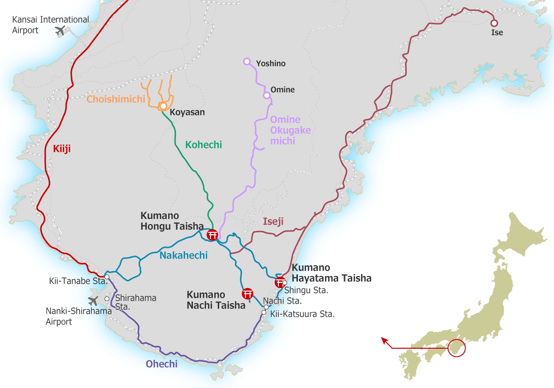
Nakahechi (Imperial Route) - 38 kilometers - 68 kilometers until Nachi Falls: the main inland pilgrimage path from Tanabe to Kumano Hongu Taisha, forested and well-preserved. This is by far the most popular route, thanks to the established tourism infrastructure, guided tours, and accommodation network. According to data from a few years ago, 80% of the travelers who visit Kumano Kodo hike the Nakahechi Route.
Iseji (Eastern Route) - 170 kilometers: the long approach from Ise Grand Shrine to Kumano Hayama Taisha, with varied terrain, (gorgeous) stone-paved paths like Magose Pass, and many coastal sections featuring small fishing villages. This is the best route to witness coastal rural village life in Japan and, in parts, sadly, to catch a glimpse of the country's semi-ghost towns, which are grappling with severe depopulation.
Kohechi (Mountain Route) - 70 kilometers: a demanding high-mountain traverse linking Mount Koya to Kumano Hongu Taisha, with steep passes and remote ridges.
Ohechi (Coastal Route) - 120 kilometers: a seaside route along the Kii Peninsula from Tanabe to Kumano Nachi Taisha, with ocean views but not as many well-maintained sections as in other routes.
Hiking Nakahechi: Nachi Falls to Takijiri
For our Nakahechi hike, due to accommodation constraints and the fact that I could take only one day off work to extend the long weekend, we had just four days.
Our original plan was to start at Nachi Falls and cover as much ground as possible toward Takijiri. We would stay in Koguchi for two nights to tackle the Ogumotori-goe and Kogumotori-goe sections, and then move on to Kiri no Sato in Takahara, one of the loveliest lodges on the route, for our final night, after completing the Hongu Taisha to Hosshinmon-oji section.
While the more common way to hike the Nakahechi Route is to start at Takijiri and finish either at Kumano Hongu Taisha, or at Nachi Falls, the difficulty of securing accommodation for three people (though we were also okay to split up to different lodges if needed), required us to reverse the route, starting at Nachi Falls, and aiming to finish at Takijiri.
I certainly get the appeal of finishing the hike at Nachi Falls. It is an iconic site featuring Japan`s highest single-drop waterfall, right next to one of the three sacred shrines of Kumano - Nachi Taisha. The scenery, depending on the waterfall’s strength that day, serves as a visual crescendo, a perfect way to mark the end of the journey.
Walking the route in reverse, however, also had its advantages. First and foremost, I loved the idea of staying at Kiri no Sato Lodge in Takahara on the last night of the hike, rather than on the first, with many kilometers left to cover and long before the celebratory mood kicks in. It is a lodge to relax in and take your time at, rather than merely a place to sleep before moving on.
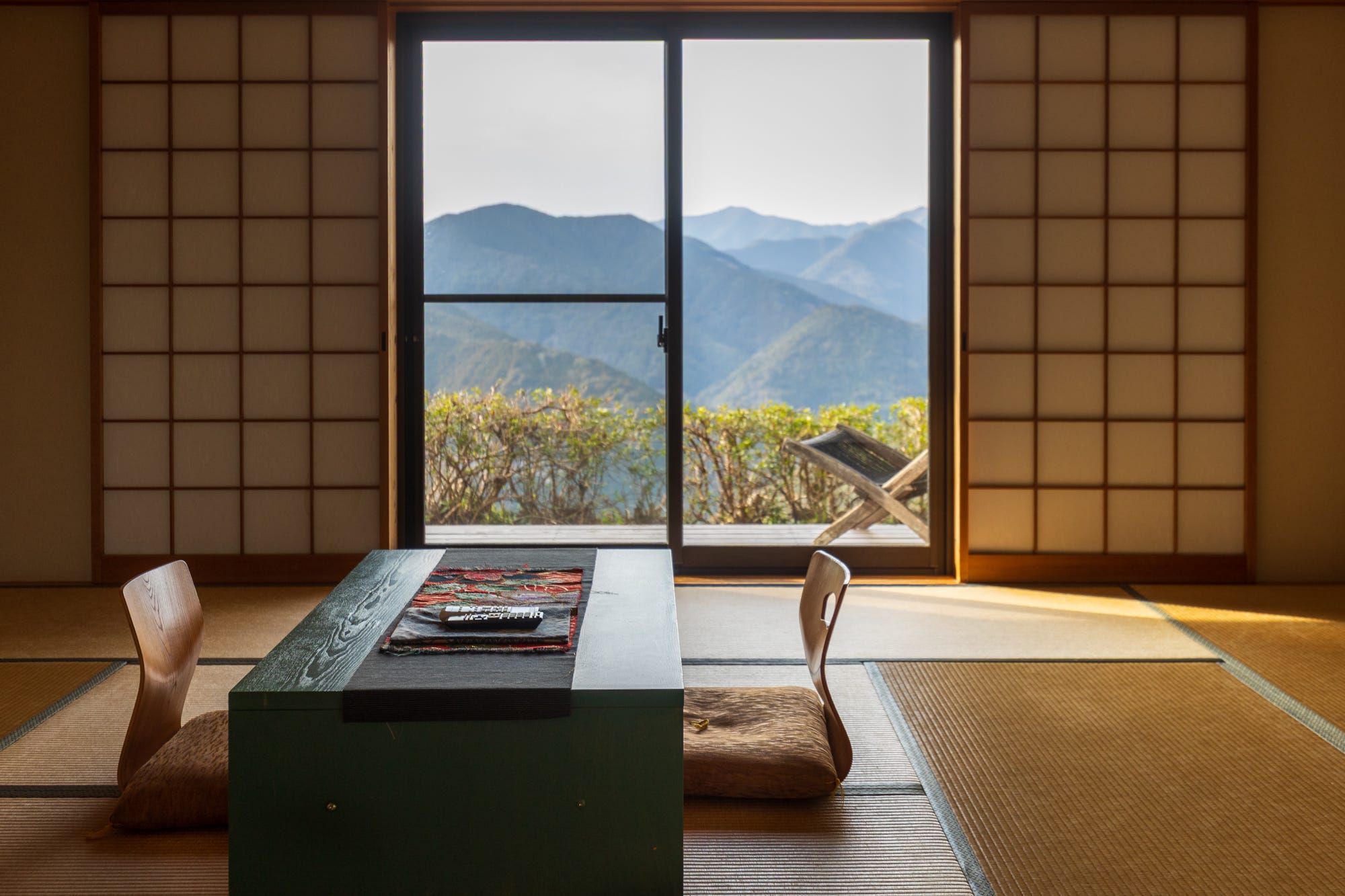
This time, it felt especially nice to arrive in Takahara early in the afternoon, settle into our comfortable rooms, enjoy the lovely bath, the private decks overlooking the mountain range, and, of course, the excellent food prepared and served by the lovely family running the entire operation.
Starting at Nachi also reduced the total elevation gain for the notoriously difficult Ogumotori-goe section we covered on the first day, bringing it down by about 330 meters, to around 930 meters. The stretch connecting Nachi Falls to Koguchi, once known as the body-breaking route, is still considered the most difficult part of the Nakahechi Route.
Looking back, if I revisit the Nakahechi, I would - accommodation permitting - hike it in this reverse order again.
Below is how we planned the hike, and how it unfolded in practice.
Day 0: Tokyo to Shingu
To start as early as possible on the first day of the hike, the longest of the whole trip, we left Tokyo a little after 5 p.m. We first took the Shinkansen to Nagoya, then switched to the Nanki limited express for the 3.5-hour ride to Shingu, our destination for the night.
We booked the private room on the top floor of Ajito Hostel, which I can highly recommend should you end up in Shingu. They offer automatic check-in, allowing for late-night arrival, which can otherwise be difficult to arrange in rural Japan.
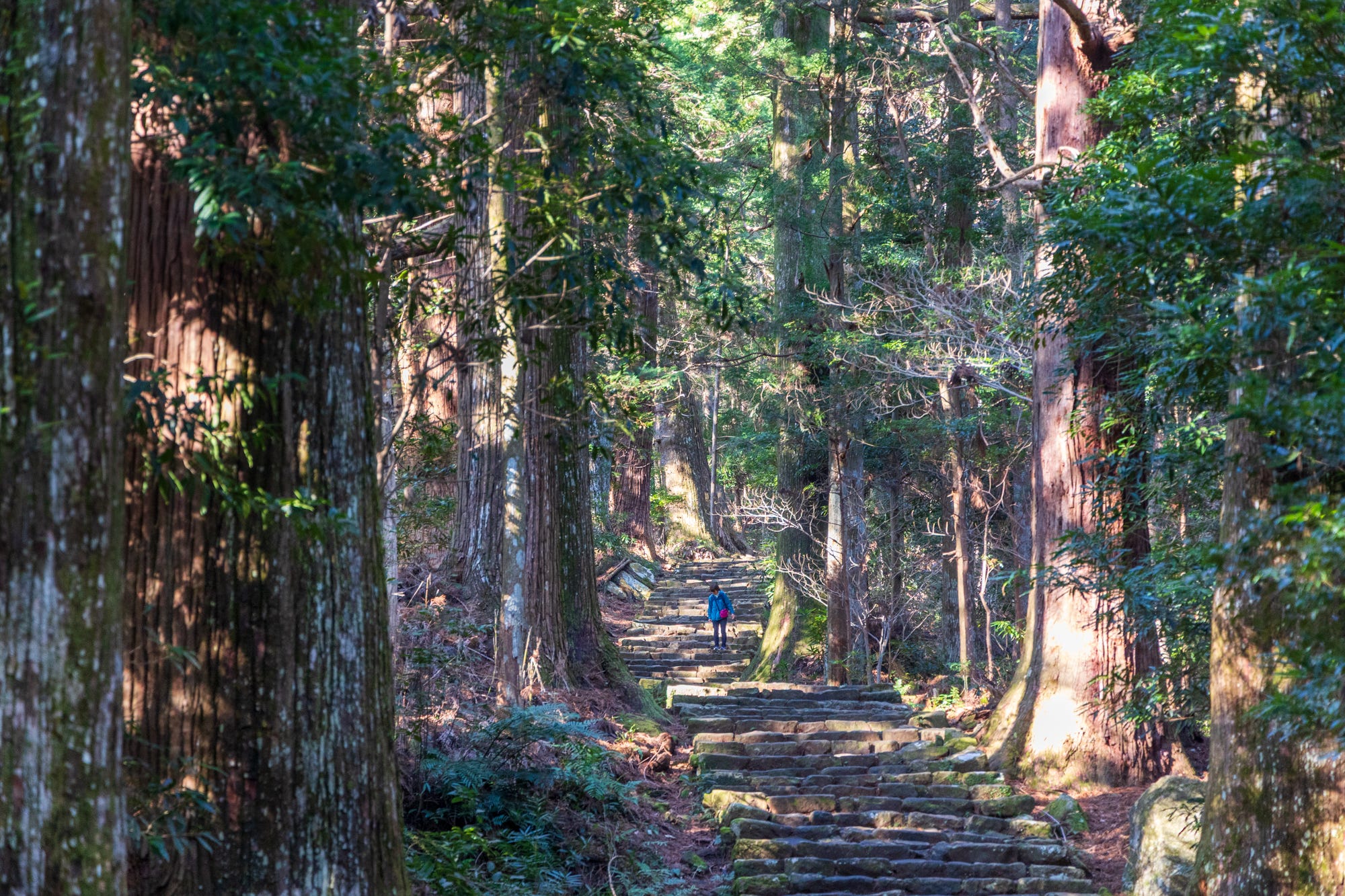
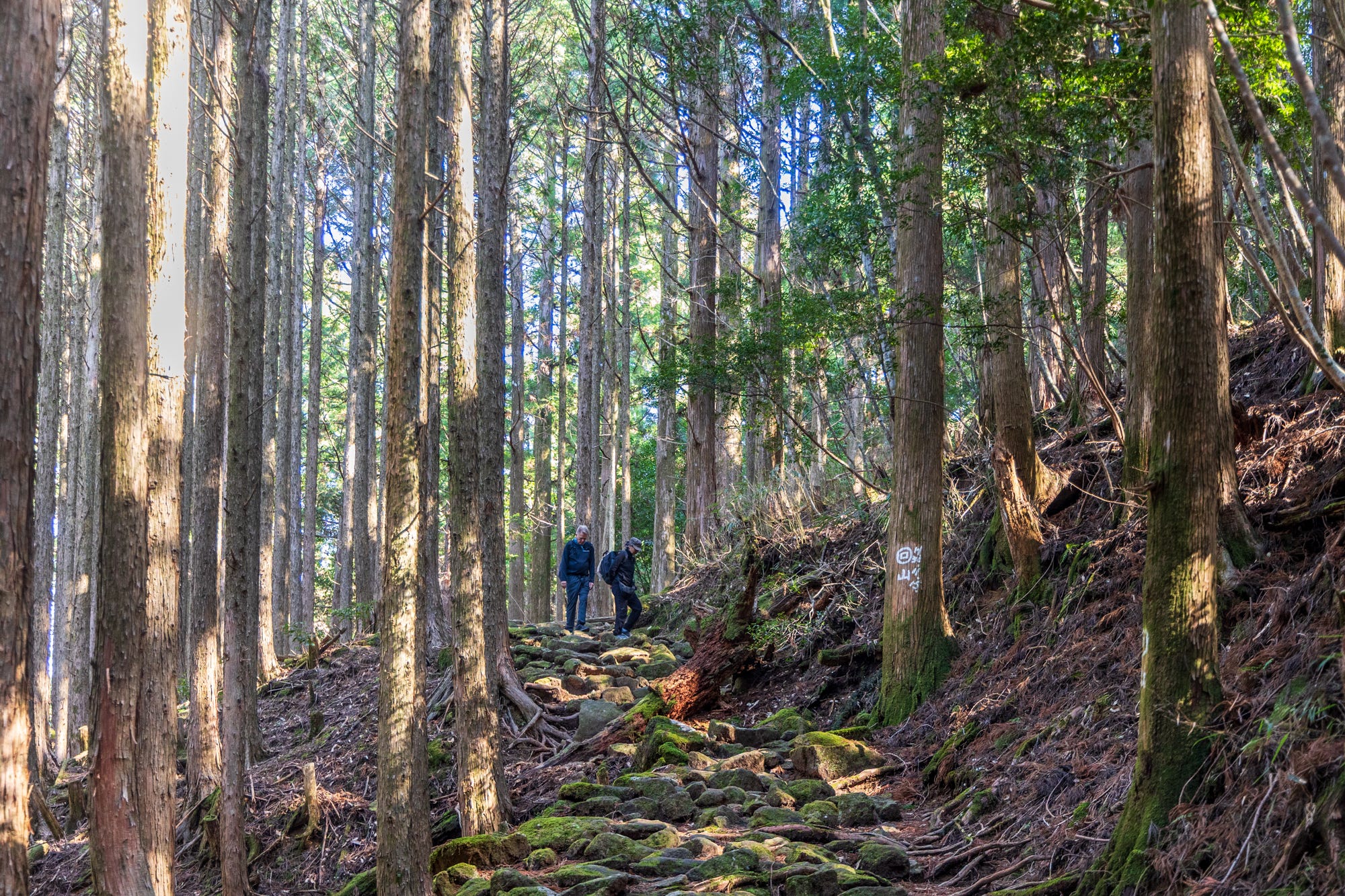
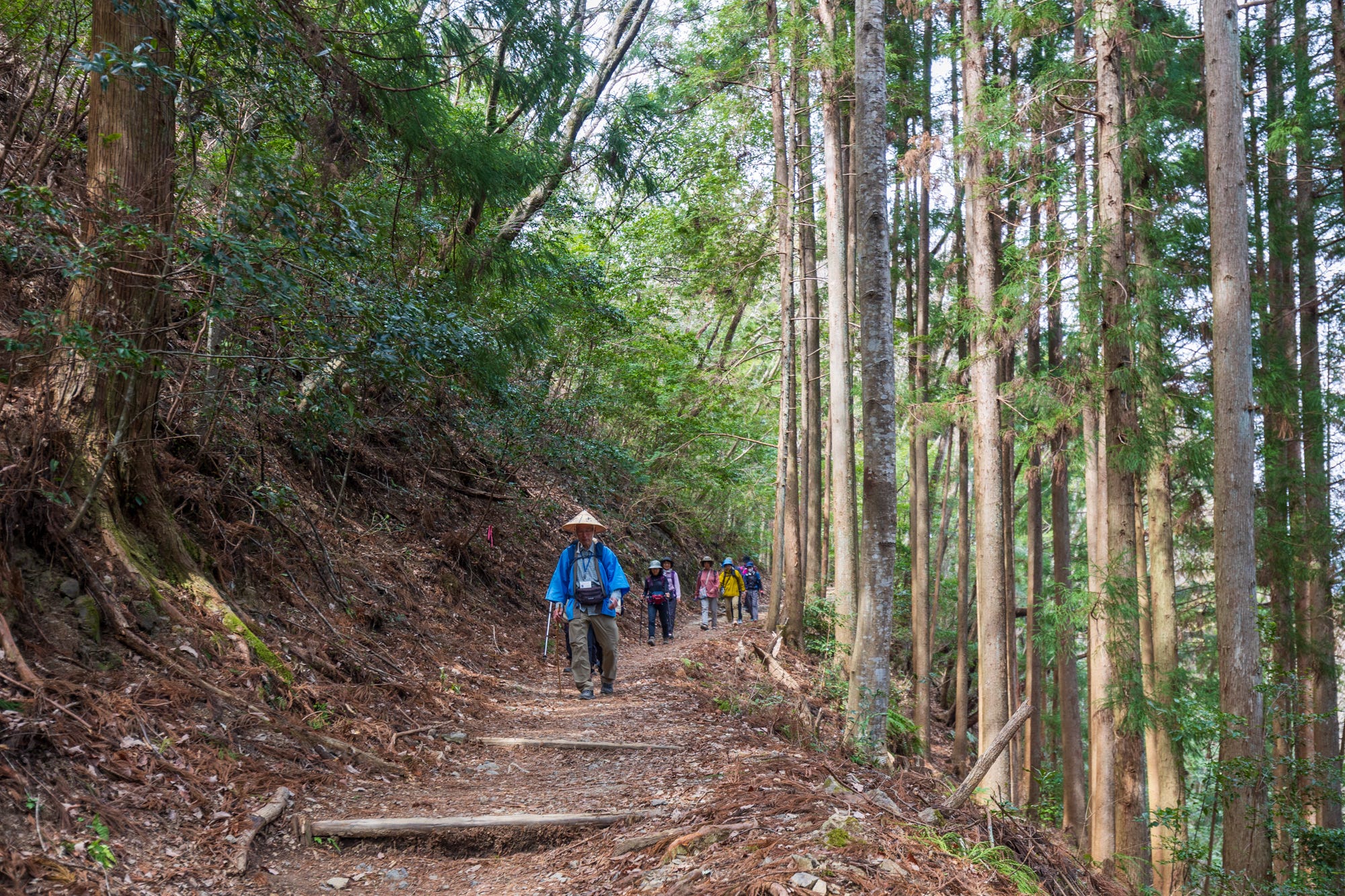
Day 1: Hiking the Ogumotori-goe - the trail of the “big clouds” connecting Nachi Falls to Koguchi (14 kilometers)
On our first real trail day, we took the earliest bus to Nachi Falls, arriving at the foot of Daimon Zaka at around 8 a.m.
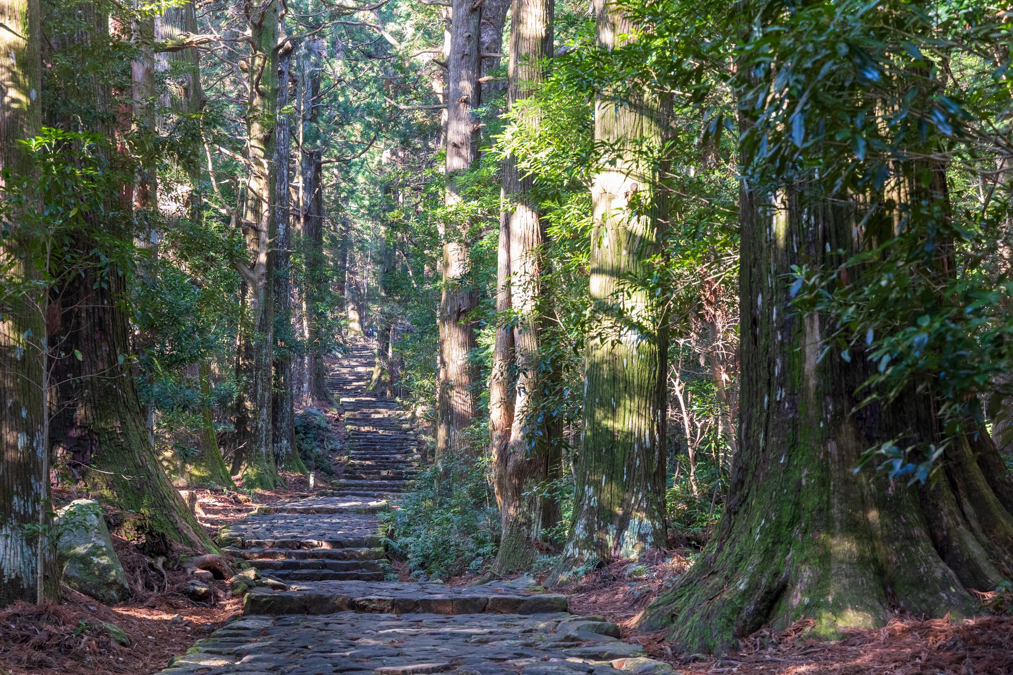
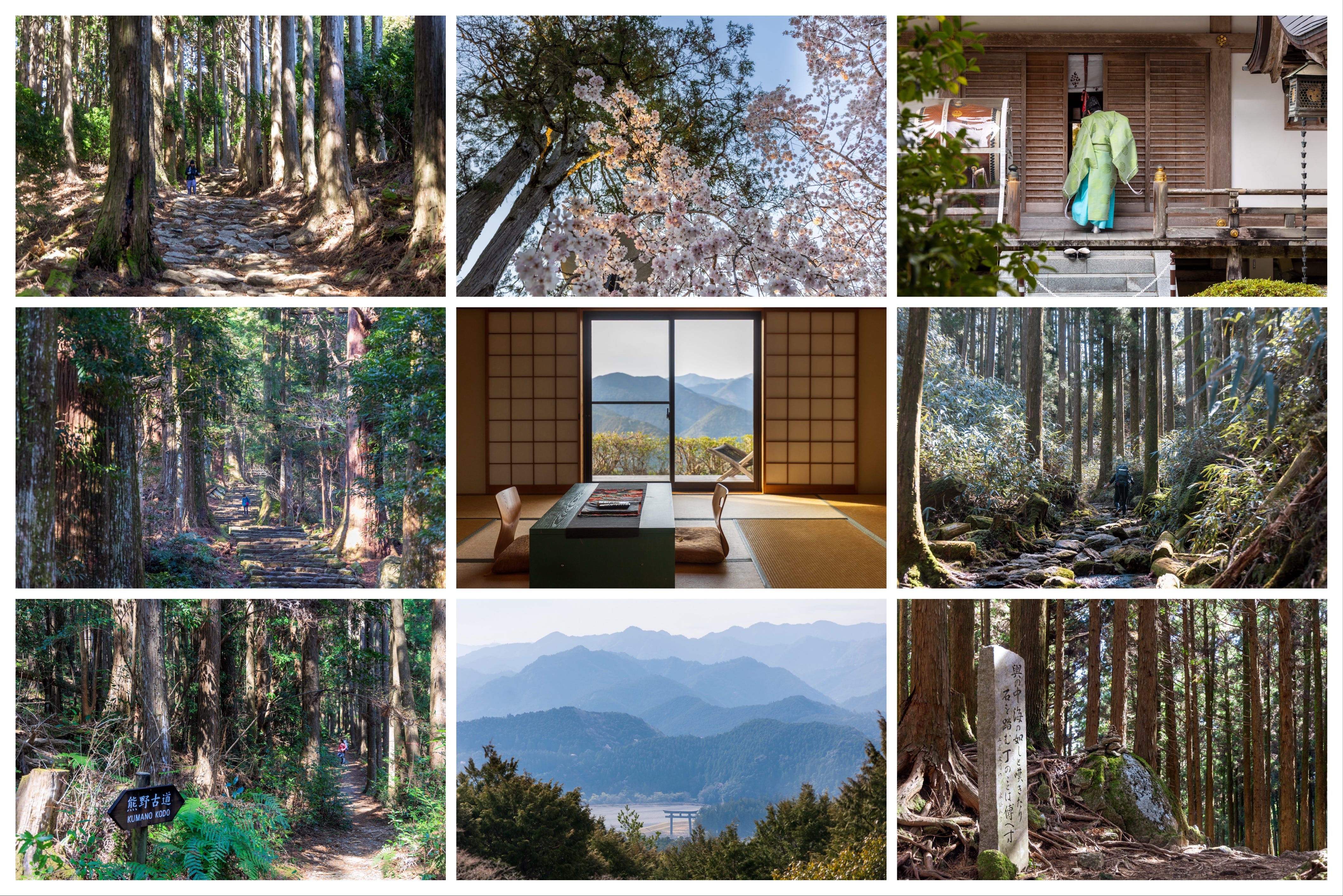
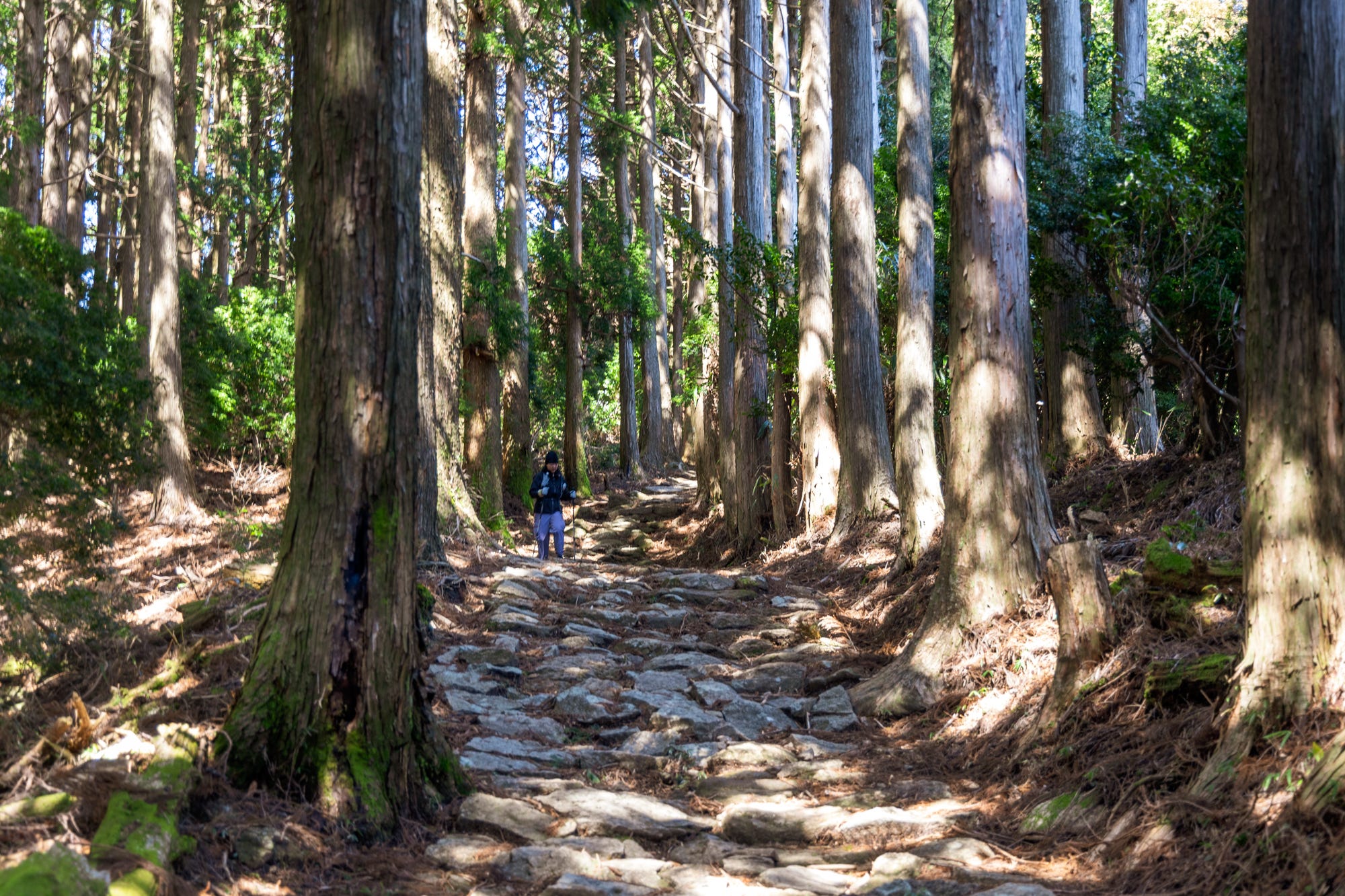
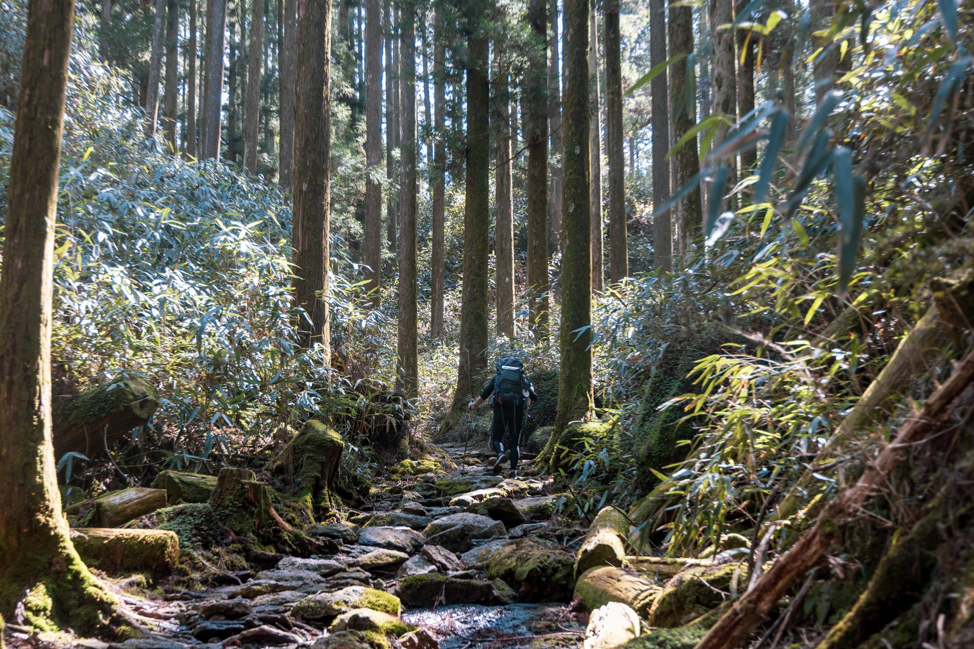
This first section, a 600-meter-long cobblestone, moss-covered staircase guarded by centuries-old cedar trees, is one of the scenic highlights of the trail and an attraction in its own right, drawing hundreds of visitors every day.
The stone stairs immediately convey a sense of “ancientness” and perfectly set the mood and visual tone for the experience ahead for those about to wander deeper into Kumano Kodo.
Knowing that we would likely have at least 6-7 hours of hiking ahead of us, and that the sunset would be a little before 6 p.m. in late March, we spent minimal time at the waterfall area, which is about a 30-minute walk from Daimon Zaka, and started the hike at around 9.30 a.m.
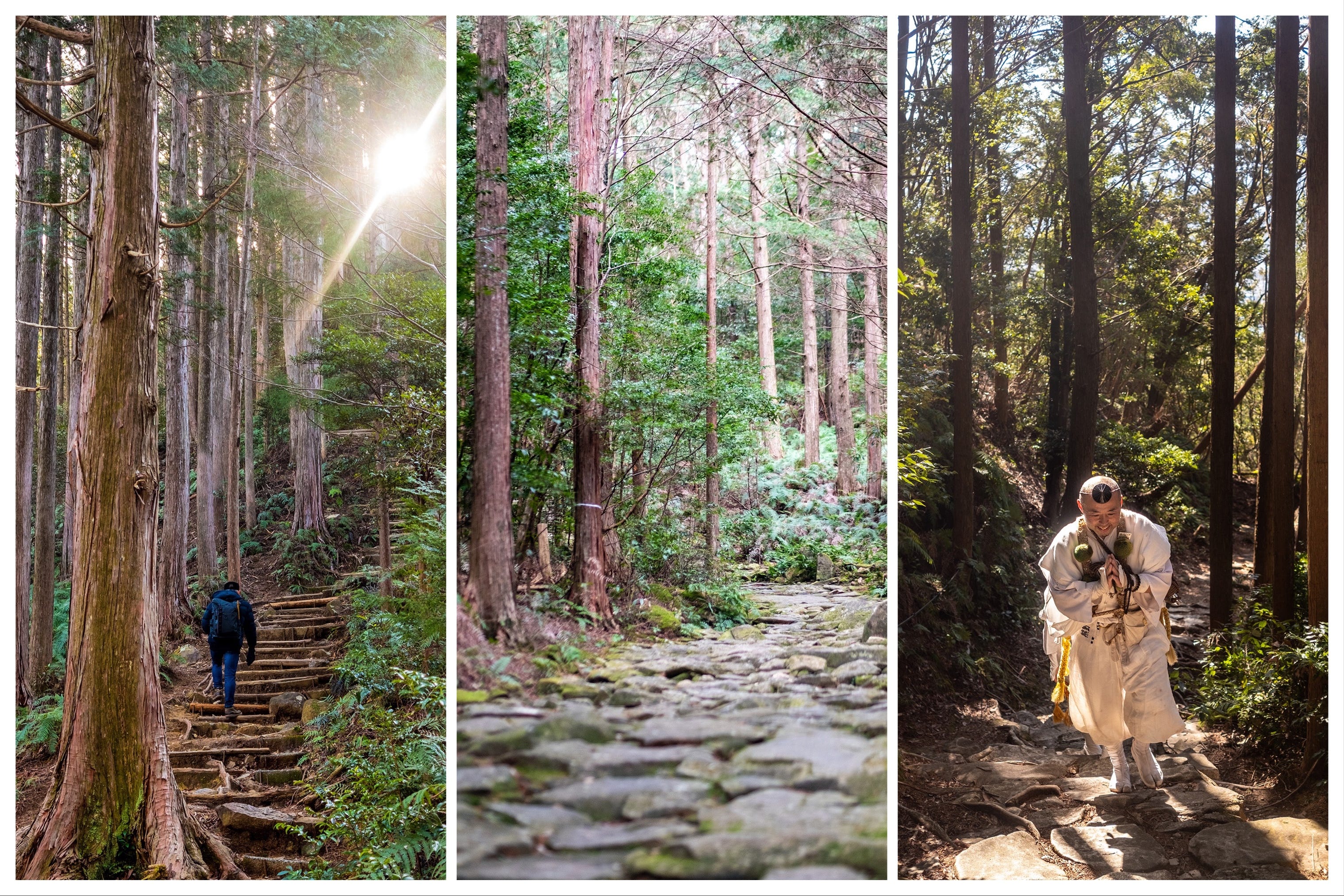
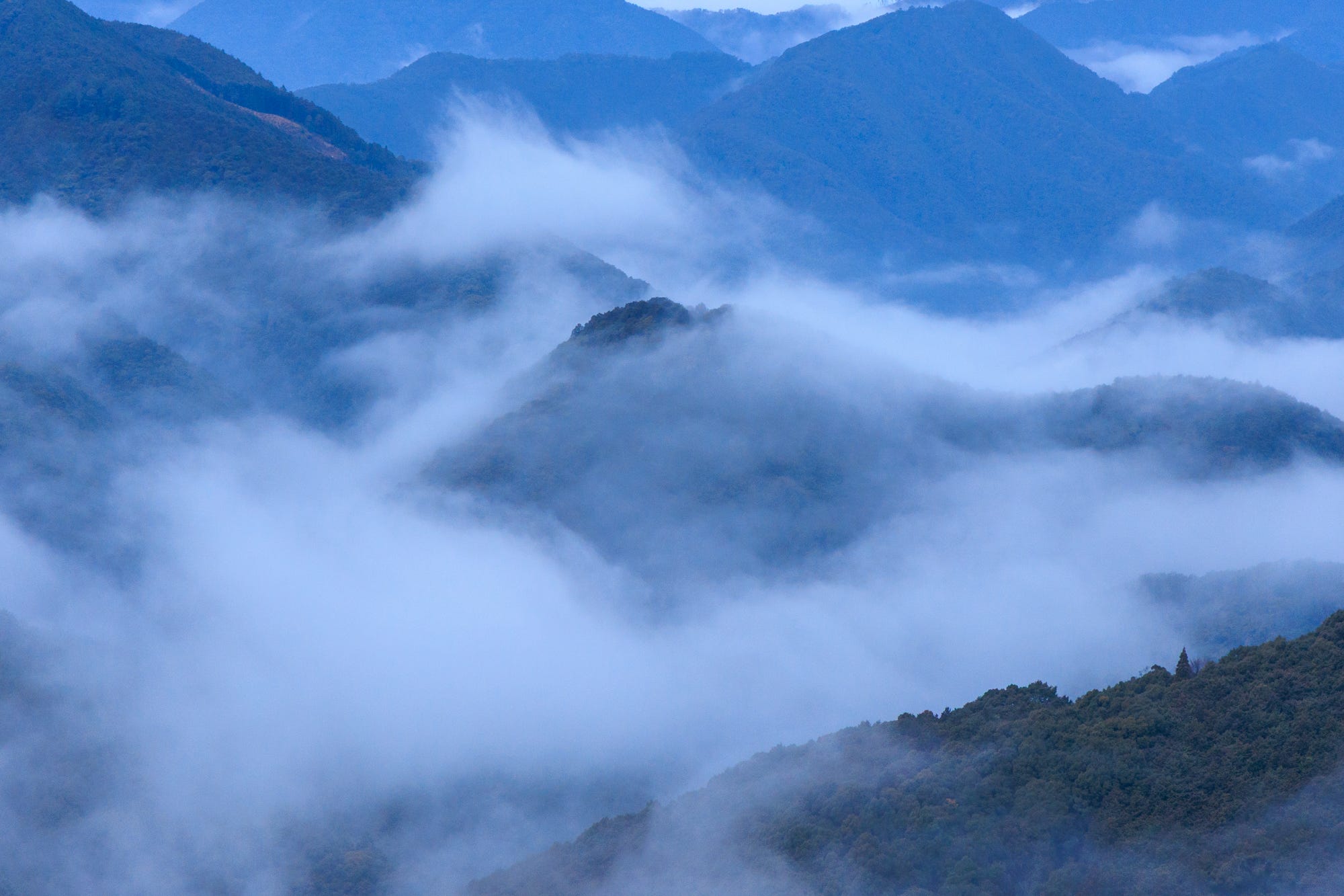
Ogumotori-goe, which literally means “big clouds gathering slope”, true to the centuries-old rumors, turned out to be the most decisively steep section of all the trails I hiked in Kumano Kodo, including another notoriously difficult one, Yakiyama Pass along the Iseji Route.
But if you are familiar with Japan’s hiking trails, you will be mentally ready for the trail’s offerings, including the steep climb thrown your way right out of the gate. You will also not be surprised how depressingly short the flat sections are before you need to make another steep ascent or descent. That is, unfortunately, the story of hiking in Japan, the trails of which are often keen on not giving you any meaningful break.
But, do not be discouraged, as the trail of “big clouds,” despite its challenges, is also known as the most beautiful section of the entire Kumano Kodo network.
This is the one section of Nakahechi where you get the feeling of a deep-forest hike, deliciously spooky in certain light. As the sun starts gently going down, the atmosphere starts feeling a little bit eerie, not the kind that makes you feel nervous, but helps you better connect to the thousand-year-old history of the forest.
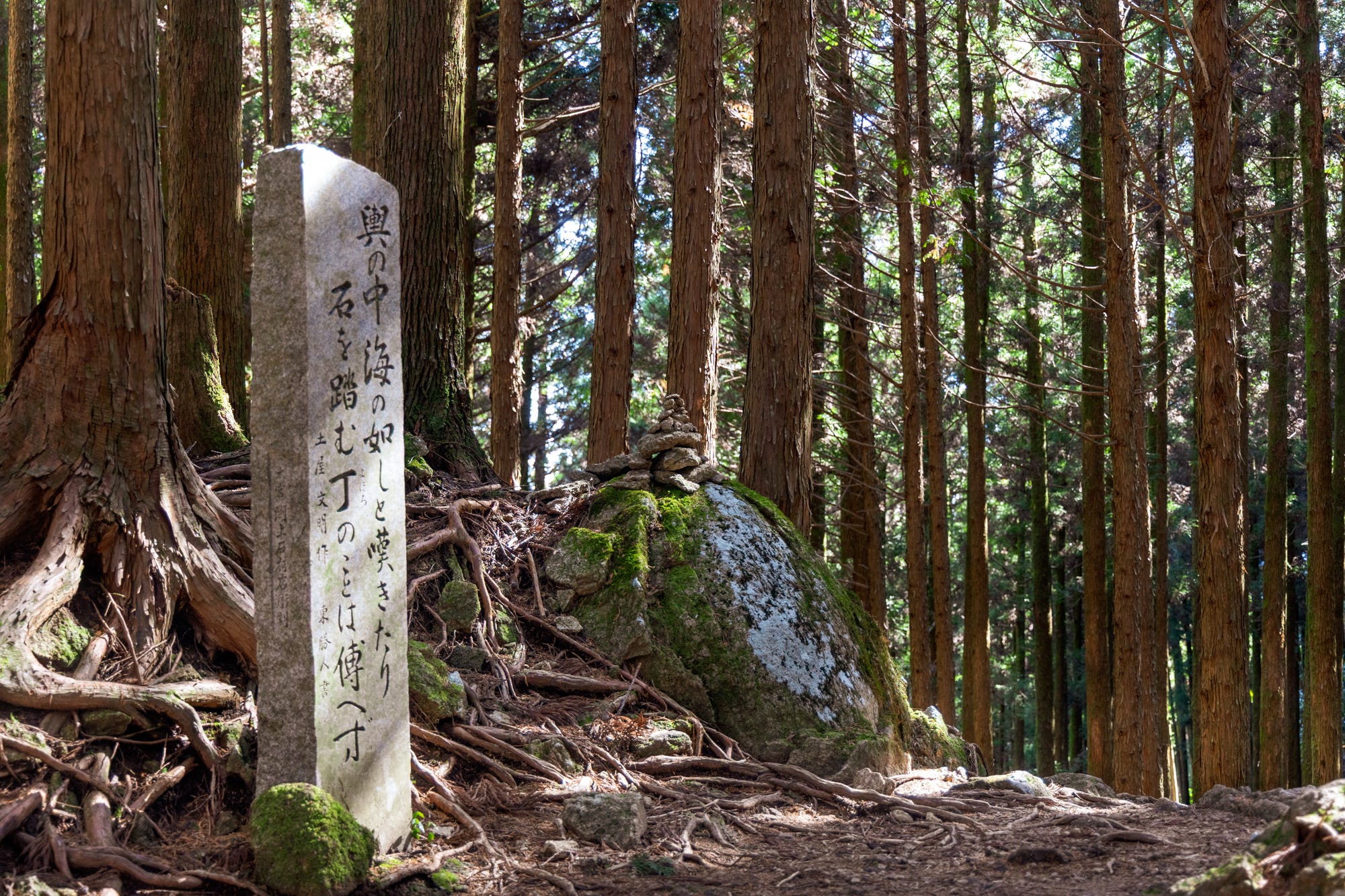
There are several “landmarks” on the trail, including the remains of the old tea houses and lodges once used by the pilgrims, as well as viewpoints. Funami-toge Pass, with views of the ocean and the seaside village of Katsuura, is the most popular and serves as an ideal lunch stop for those starting the hike at Nachi Falls, including us.
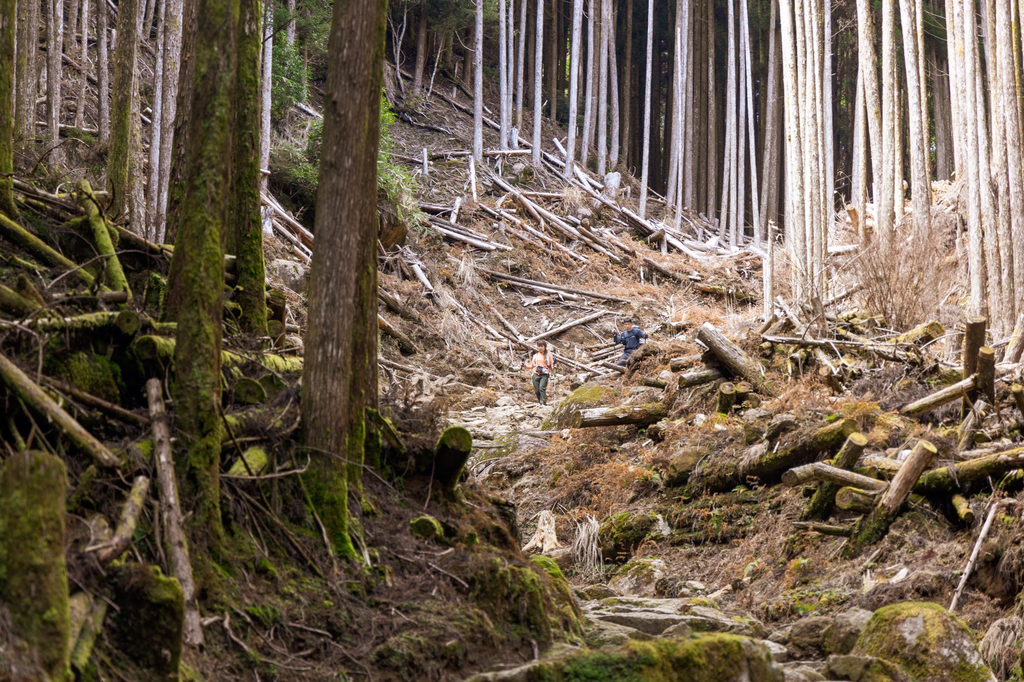
Dogiri-zaka, the most infamous or beloved section of the hike, depending on which side you start from and otherwise known as the “body-breaking slope,” involves 800 meters of elevation gain over 5 kilometers (if you begin from the Koguchi side). It is one of those segments where mossy paths and a river running alongside try their best to lure you with remarkable beauty, to distract you from the challenge they present.
Admittedly, coming from the Nachi Falls side, we did not have to face the crueler side of this climb, which was a descent in our case. But judging from the faces of the hikers coming up from the Koguchi side, beauty may not have been the answer to all the world’s troubles. They looked as though they would wholeheartedly agree with the 12th-century poet Fujiwara no Teika, who described (or not described) the trail as follows: “This route is very tough and difficult; it is impossible to precisely describe how tough it is.”
We ended the first day’s hike, which took us around 7 hours, at the Koguchi trailhead, where our host for the next two nights kindly picked us up (there is also a public bus). There is a general store a few minutes off the trail exit, which is your only option for some food and drinks in the area.
We stayed at Satsuki Apartments, which offer clean, basic, standard Japanese-style two-bedroom apartments with a kitchenette, a dining table, and a bathroom. A simple breakfast, including bread, cheese, salami, coffee, and cereal, is also provided and stored in your fridge daily.
In addition to the unatmospheric but highly functional apartment, one other thing that made our stay in Koguchi worthwhile was the local onsen, which was just a few minutes’ walk from our accommodation. It was one of those very local but extremely well-managed community onsen, with spacious indoor and outdoor bathing areas. For 500 Yen per visit, it was wonderful to know that we could wash off the day’s hike in such a cozy environment.
Day 2: Kogumotori-goe: the trail of small clouds connecting Koguchi to Ukegawa (13 kilometers)
Kogumotori-goe, which we covered on the second day and which connects Koguchi to Ukegawa, was the most pleasant surprise of the hike.
I was already aware of Ogumotori-goe`s scenic fame, and previously hiked the third day’s segment - the short trek between Hongu Taisha and Hosshinmon-oji. As for Kogumotori-goe, however, I had only a vague assumption that it would be a shorter, slightly easier version of Ogumotori-goe, based loosely on its name - “small cloud gathering pass,” as opposed to Ogumotori’s “big cloud gathering” version.
The trail, fortunately, offered a significantly different experience, packing in a wide variety of landscapes in its relatively short 3- to 4-hour duration.
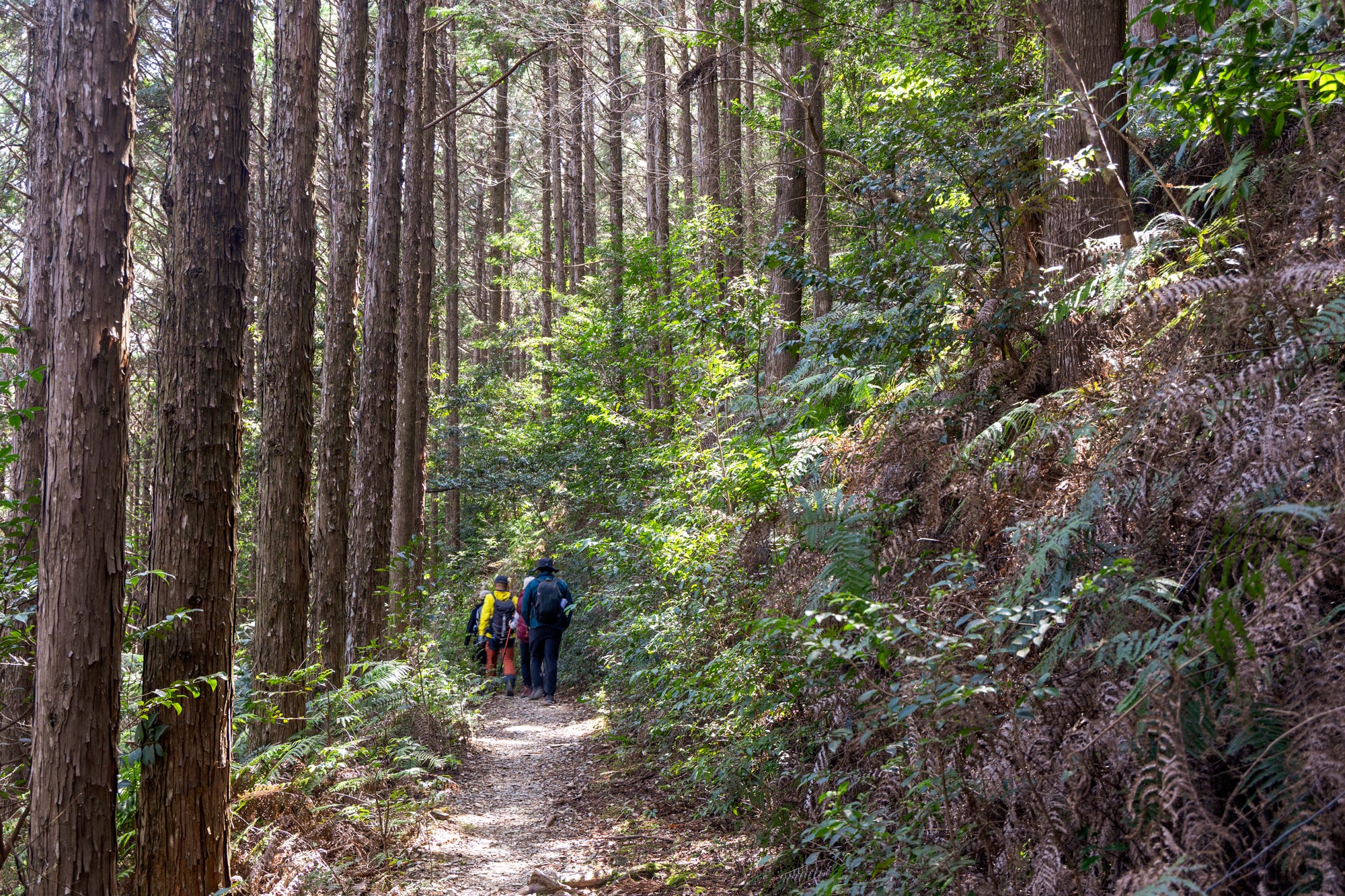
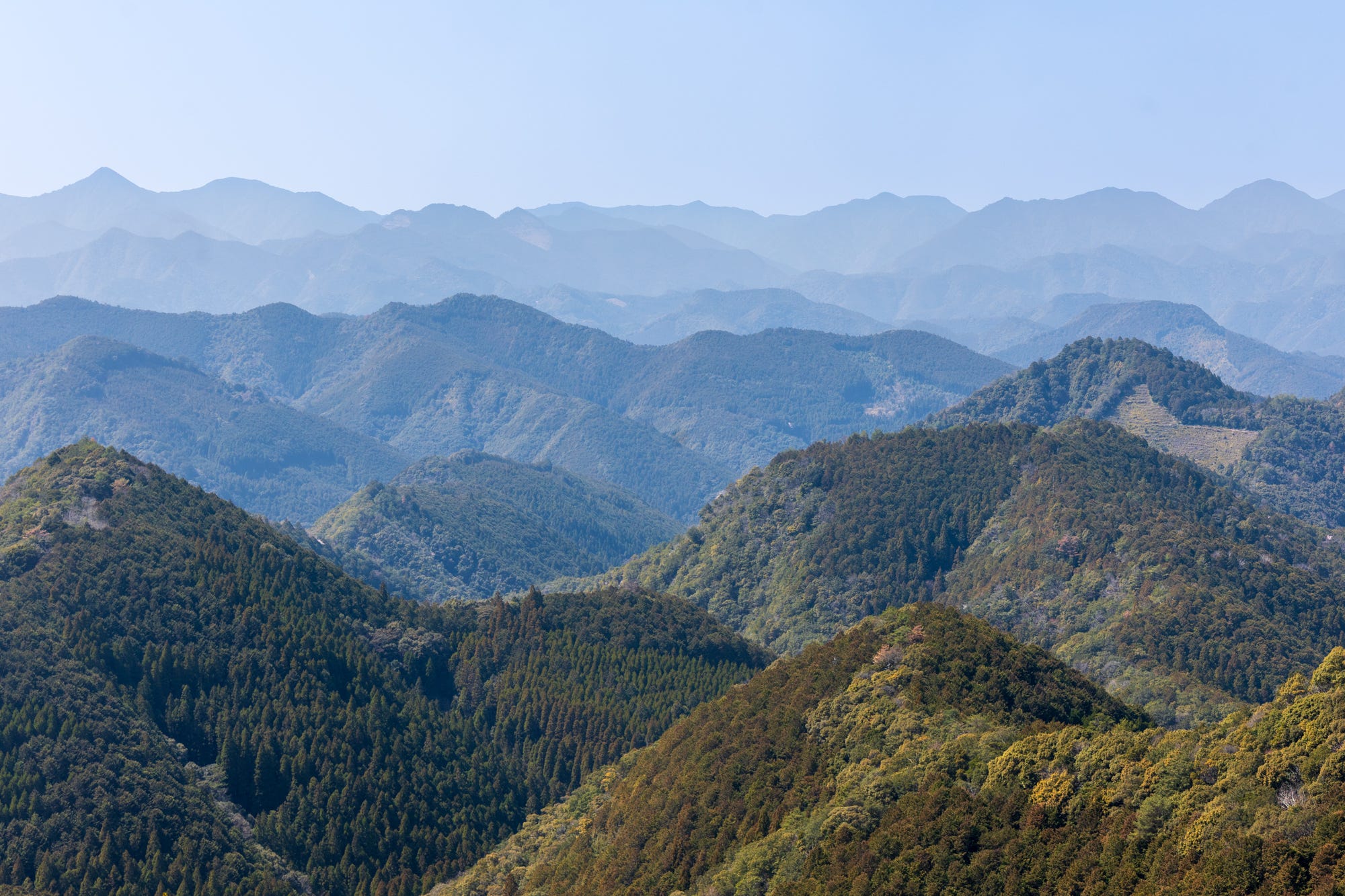
Starting with a striking cobblestone section, the path gently climbs towards a ridge, then alternates between open, fern-dense sections and deep-forest walks, before reaching Hyakken-gura, the viewpoint overlooking the expansive mountain ranges of Kumano. This is the point from which many of the iconic Kumano Kodo shots are taken by those who make the effort to hike up to it at around sunset.
During our hike, which happened to be on a Saturday, we ran into many hikers, and everyone seemed in a good mood, with the ratio of smiling faces to those questioning the very meaning of life far exceeding what we encountered on the Ogumotori-goe.
There was, of course, a valid reason. In terms of difficulty, Kogumotori-goe is significantly gentler than its big brother, as there are long stretches of entirely flat sections, with the occasional climbs that are nowhere near as steep to be described as a “body-breaker”.
It took us somewhere between 3 and 4 hours to cover the section before we landed in Ukegawa, a very small town with a sparsely stocked convenience store, a tiny general store also stocking some fresh vegetables, and a surprisingly high number of bus stops.
While we had the option to extend the walk to Hongu Taisha by following a main road for about 50 minutes, we decided to take the bus.
The afternoon was spent in Hongu, visiting the shrine, taking a walk towards the world’s largest torii gate, Oyunohara Otorii, which we would be looking down on from above the next day, and stopping by the Kumano Kodo Information Center, famously built with locally sourced wood and featuring a number of video and photographic exhibits, before taking the bus back to Koguchi.
Day 3: Hongu Taisha Shrine to Hosshinmon-oji (7.5 kilometers)
Our original plan for the third day was to cover two short sections: first, the Dainichi-goe, connecting Yunomine Onsen town to Oyunohara in 1-2 hours; and then the section connecting Oyunohara, via Hongu Taisha, to Hosshinmon-oji in 2-3 hours.
However, given the infrequency of bus service to Takahara, our destination for the night, we decided to allow ourselves plenty of time to catch the noon bus and avoid a late arrival. So we skipped Dainichi and did only the Hongu Taisha to Hosshinmon-oji section.
This 7.5-kilometer hike of very gentle climbs - possibly the gentlest trail of the entire route- is one of those sections where Japan throws hikers a rare bit of mercy, giving access to magnificent scenery without demanding much physical effort in return.
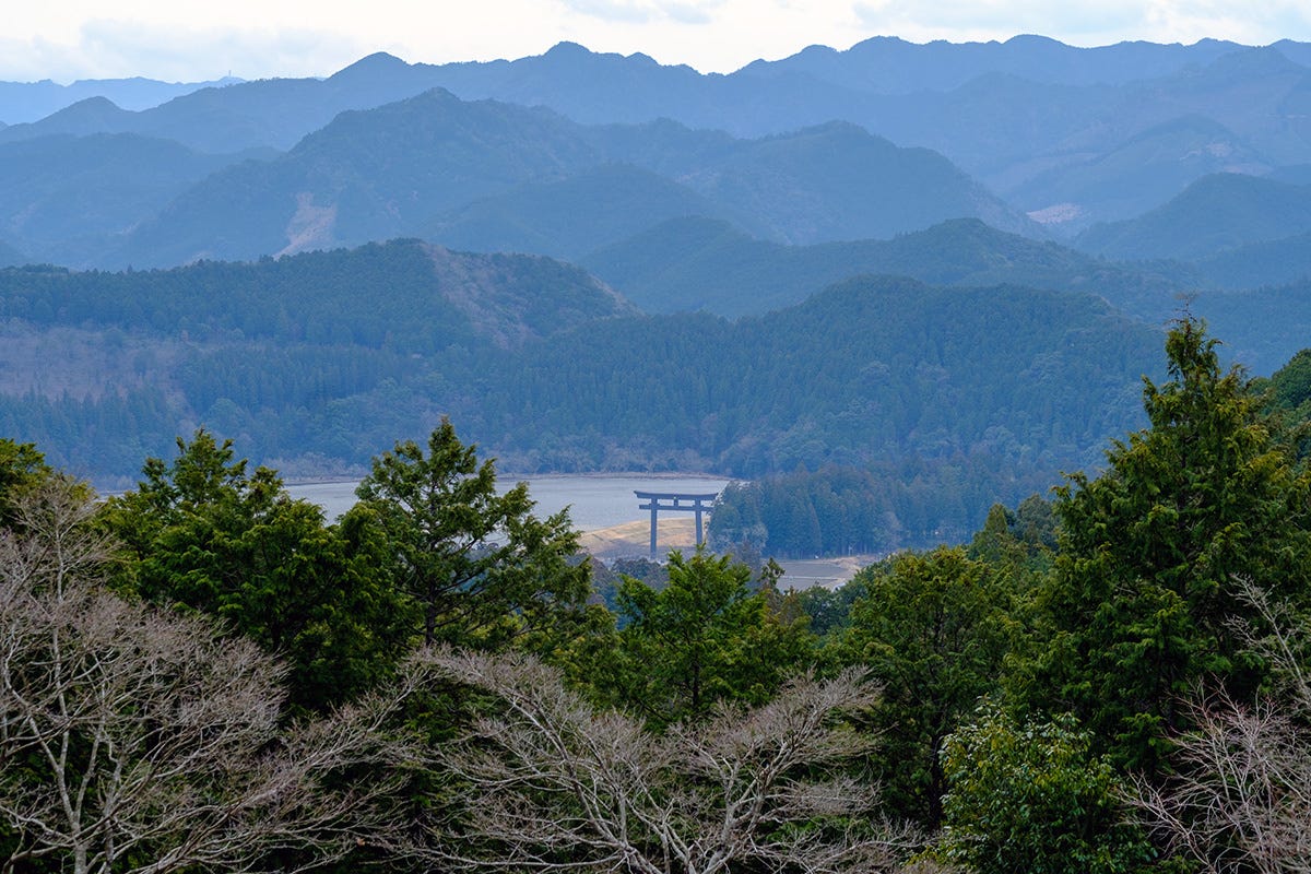
There is only one steep climb, but a very short one, that makes a detour to the viewpoint halfway between Hongu Taisha and Sangen-jaya, offering the view of the giant Oyunohara Otorii against the silhouette of the Kumano mountain range.
The majority of the trail runs through forests, with occasional dips into tiny settlements. We also came across a small coffee house, serving snacks and coffee made with onsen water.
It took us around two hours to reach Hosshinmon-oji, which is one of the major “side” shrines along the Nakahechi Route.
Oji are the subsidiary shrines of the three main shrines of Kumano, the Kumano Sanzan, that line the route to protect the pilgrims. Hosshinmon-oji - 発心門王子 - meaning the gate of spiritual awakening, marks the outermost entrance to Kumano Kodo’s sacred grounds.
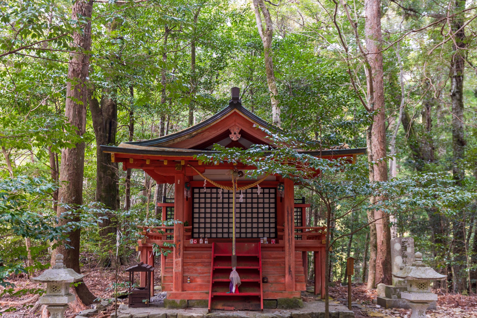
Given the significance of this unassuming but beautifully colored oji, the section of the trail connecting Hongu Taisha to Hosshinmon-oji is also very popular with day hikers. So, if you visit the area and do not wish to commit to a full-day hike, this short but memorable section is a great way to get a quick sense of the Kumano Kodo experience.
We ended the third day at Kiri No Sato Lodge in Takahara, after a 1.5-hour bus ride from Hosshinmon-oji.
The afternoon and evening were spent enjoying the view, the relaxing music, the bath, and the wonderful food, while mingling with another group of hikers who were fortunate to stay at the lodge for two nights.
Day 4: Takahara to Chikatsuyu (aborted), and back to Osaka/Tokyo
Our plan for the final day of our hike before traveling to Osaka, where my friends would stay the night, while I would take the Shinkansen back to Tokyo, was to walk the section between Takahara and Chikatsuyu.
After a roughly four-hour hike, we would take the bus to Tanabe on the western coast of Wakayama, then the Kuroshio Express Train to Osaka. Following one final meal together, we would part ways until my friends returned to Tokyo for their last leg of the trip two weeks later.
Well, we managed to stick to our original plan for a good portion of it, including the mandatory trip to Osaka via Tanabe, and one last meal before goodbye, with one minor exception: the hike itself.
Due to an unrelated and unforeseen development in the morning (and no, we did not get into a fight), we decided to forgo the day`s walk and travel to Osaka soon after breakfast.
So, the end of our hike was rather unceremonious, but we were glad to have a night of relaxation, and even a bit of celebration, evidenced by the number of empty wine bottles at the end of the meal, at Kiri no Sato to mark the end of the trip, not knowing that we would have to leave the trail earlier than intended the following day.
Throughout the three days we were on the trail, we had the benefit of sunny skies, allowing us many moments of komorebi. The only thing I regret is not being able to stay in Yunomine for one night, instead of a second night in Koguchi.
Yunomine would not only make perfect sense logistically (we would not have to skip the Dainichi-goe), but it is also a lovely town to stay in, adding a bit of an additional rural touch to the whole experience. My friends would also get to experience Japan's reportedly oldest onsen, Tsuboyu, and its cobalt-blue water, which I previously visited twice.
Kumano Kodo - Quick FAQ
While the FAQ below is by no means comprehensive, it brings together some of the common and a few anticipated questions about hiking the Kumano Kodo. For non-destination-specific planning sources, you can refer to the Japan Trip Planning Index and the Frequently Asked Questions section on my website.
#1 How to book the Kumano Kodo hike?
There is no permit requirement for the Kumano Kodo, or a specific booking process for the hike. So you can basically get to the trailhead and start walking.
However, since it is a multi-day trail, with free camping along the route not being allowed (more on this below), and with no designated hikers huts like you can find in New Zealand, you will need to book accommodation at several different places, ideally at different towns/locations following the trajectory of your hike, or commit to one place, and use public or private transportation to get back from and back to where you left off the trail each day. And that is the increasingly challenging part, addressed below.
#2 Is there a centralized accommodation/service booking website?
The question is, I suppose, a bit too specific for the answer to be “no”, so yes, there is one.
The community-run Kumano Travel website is the one-stop shop where you can technically arrange all services related to your hike, including accommodation, guide arrangements, luggage forwarding, guidebook purchases, taxis, etc.
The site was already in operation when I first hiked Nakahechi in 2018. At that time, I could arrange everything fairly swiftly through the site. But this time, no such luck.
While we did not use luggage forwarding or arrange a taxi, I still tried to use the site to book accommodation. However, after a few tries, I quickly gave up. There is no instant booking system. You need to send a request to each accommodation based on the availability calendar, and then wait to hear back from them. In my case, despite the calendar showing availability, I received my rejections within a few days of sending the request. I hear the reply period may take even longer, leaving you in limbo, unable to finalize the itinerary.
There is also a limited time window during which you can submit booking requests through the website - daily 7:00–9:30 and 19:00–22:00 (Japan Standard Time), which can also be a little challenging.
So how did we book the accommodation?
#3 How to book accommodation for Kumano Kodo?
Now, that is the discouraging part. While Kumano Kodo, especially Nakahechi, is, along with Shimanami Kaido Cycling Route, one of the most organized outdoor/culture tourism experiences Japan has to offer, supported by a resourceful tourism office behind, I found the accommodation booking experience for this recent Nakahechi outing one of the most challenging booking experiences I have had in Japan.
Admittedly, we did the hike on a long weekend in late March, one of Japan's peak travel seasons, driving up the domestic demand alongside the international one, but I hear the situation isn’t much different during the shoulder months.
While the number of accommodations along the route has increased over the years, demand is so high that it is usually advisable to book accommodation months in advance. Also, there is the issue of bulk room bookings by walking-focused tourism companies based in Japan, leaving independent travelers with very limited options.
So, in the end, I simply used a combination of conventional methods: Booking.com, Rakuten Travel Japan, Jalan, direct emails, and phone calls to the accommodation providers. Fortunately, many of the lodges are not exclusively listed on Kumano Travel's website and can also be booked independently through other websites. I, however, had to modify our itinerary significantly and try to make it work not the way we would prefer, but around what we could find.
Honestly, if I did not have two friends traveling all the way from Turkey for the hike, I would probably give up and choose another trail.
#4 Is camping allowed in Kumano Kodo?
Yes, and no. Free camping along the trails is strictly prohibited. However, there are several designated camping grounds in the towns along the Nakahechi Route, including one in Chikatsuyu, Kawayu Onsen, Watase Onsen, and Koguchi.
Tanabe/Takijiri and Nachi Falls, the starting points of the hikes, have no designated campgrounds.
For more information about camping, you can refer to the camping section of the Kumano Travel website.
#5 Which Kumano Kodo route to choose
My Kumano Kodo experience is limited to the Nakahechi and Ise-ji Routes. And among the two, my suggestion - quoting from February`s Hiking Japan letter, would be as follows:
“Nakahechi offers a more digestible, compact pilgrimage experience, while Iseji feels a little more secluded and offers greater landscape diversity, with more local life woven into it.
For first-time visitors, Nakahechi is probably the better fit. Iseji, on the other hand, may be better enjoyed on subsequent visits, when a bit more familiarity with Japan may help you to appreciate the deeply rural and sometimes ghostly scenery in a more generous context.”
#6 Is there a luggage forwarding service?
Yes. This is the one aspect that the Kumano Travel website makes very easy to arrange.
Though a little more expensive than the nationwide used TA-Q-BIN luggage forwarding services, Kumano Kodo has its own network of dedicated transportation and luggage forwarding service providers. Pricing is quoted per piece of luggage and starts at around 4,000 Yen. You can check out the options here: Kumano Kodo Luggage Forwarding.
#7 Should I add Koyasan to my itinerary?
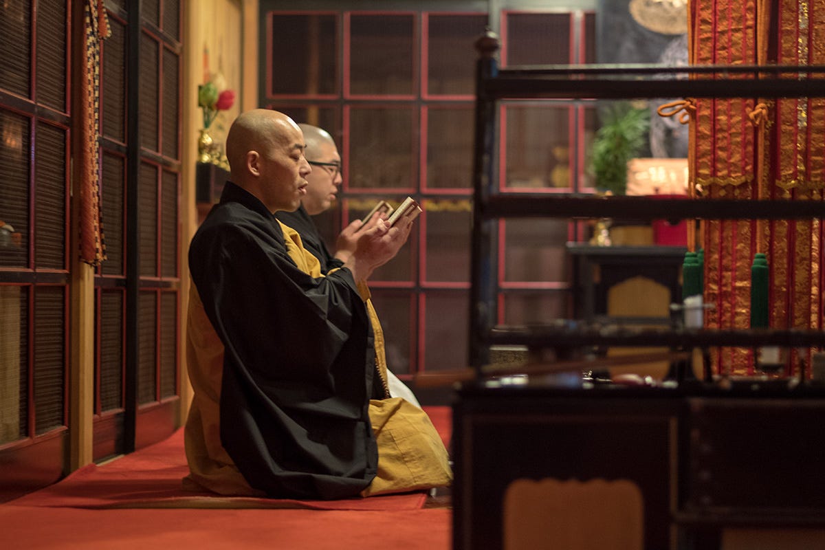
If you hike the Kohechi Route, you will inevitably end up in Koyasan, the mountaintop temple village of Mount Koya, long considered one of the most important centers of Buddhism in the country, home to over a hundred temples and the atmospheric Okunoin cemetery, where the founder of Shingon Buddhism, Kukai, is said to rest.
It is also not uncommon for those who hike the other routes to take a bus to Koyasan at the end of the hike and wrap up the whole experience with a temple stay. And if you had asked me a few years ago whether this addition to the itinerary would be worth the trouble, I would have said definitely yes, when temple accommodation was still relatively reasonably priced, offering a relatively affordable and wonderful end to an already spiritually charged experience.
This time around, we also considered ending our hike with a one-night stay in Koyasan, but over the years, the cost of a temple stay there has become so discouragingly expensive. I remember paying around USD 150–200 a night back in 2018 at Joki-in Temple, whereas now we could not get any quote lower than USD 700–800. So it remained just an idea rather than becoming a reality.
If cost is not an issue, I would say the experience, joining the monks for 5 a.m. morning prayers, enjoying shōjin ryōri (Buddhist cuisine) prepared with seasonal ingredients and served in your room, and having easy access to dozens of significant landmarks just outside the temple, would make for a memorable addition to the whole journey. But whether it is worth nearly a thousand dollars, I’m not so sure.
While most temples are also listed on other common booking sites, this site lists them all together: the Koyasan Temple Lodging Association.
#8 Any other trip planning sources you can recommend?
Many. I would highly recommend the Kumano Kodo Official Guide, which you can order through the Kumano Travel website (international shipping available). The guide offers a great overview of the trails, with a focus on Nakahechi, and the historical context for a more informed hike. The whole package comes with a map and other helpful brochures. It is, however, a relatively heavy book, so it is more useful for pre-trip research and preparation than as an on-trail guide.
The Kumano Travel website also offers helpful PDF maps, along with elevation info and average trail times: Kumano Kodo Nakahechi Elevation Chart.
There are also many wonderful blogs and articles online that offer a comprehensive overview of the Nakahechi and Iseji Routes. For the latter, Craig Mod`s Ise-ji Walk With Me is a very useful source, while AFAR's Kumano Kodo - Nakahechi story is one great source of inspiration. For other routes, David of Random Wire offers a detailed diary of the Kohechi Route.
If you would like to get a visual sense of the Nakahechi trail, Chris and Danya`s Nakahechi vlog is a wonderful option (their other hiking videos are also very helpful and exceptionally soothing. I immensely benefited from their channel when planning my hiking trip to New Zealand a few years ago.)
#9 Is a guide necessary to hike the Kumano Kodo?
The short answer is no. The Nakahechi Route of the Kumano Kodo is one of the best-marked routes I hiked in Japan. The signposts are abundant along the entire route, and you can also rely on Japan hiking map apps like YAMAP for route finding should you need one.
However, when I first hiked the trail in 2018, I had the wonderful company of two different guides at different sections. Their knowledge of the region, companionship, and the historical and local context they provided were a wonderful addition to the trip. I am still in touch with them and consulted them while planning this recent hike.
Should you prefer to hike in the company of a local guide, here is the booking page: Kumano Kodo Local Guides.
So, this wraps up this month’s letter, or the blog post, which feels like the more accurate description this time around.
As always, thank you for being here and for your interest in this newsletter. I will be back in the usual letter format with the May edition, which will likely focus on Amakusa, the islands of prayer, the Shimabara Peninsula just to the north, and the ever-lovely Nagasaki.
Until then,
Burcu
P.S. In addition to the monthly letters, below is a quick recap of the extra itinerary and planning-focused posts available on the newsletter for monthly and annual subscribers.
Shibu Onsen and the Snow Monkeys of Nagano (February 2026)
One Fine Autumn Day in Tokyo (December 2025)
Tohoku Onsen Hopping: Four Nights, Four Hot Springs (November 2025)
Tokyo Eateries: the Non-Gourmet Version (October 2025)
Autumn Colors Trip to Aomori: Itinerary Suggestion (August 2025)
One Fine Day in Kanazawa (July 2025)
Cycling the Shimanami Kaido in Two Days (June 2025)
Japan Trip Planning Q&A Series (three posts) (February - April 2025)
Winter Trip to Biei in Hokkaido (four posts) (January 2025)
Hiking the Kyoto Trail (five posts) (November 2024)
One Fine Autumn Day in Kyoto (September 2024)
Walking Goto Islands (eight posts) (March 2024)
Link to the website - Letters from Asia, where I first posted it - version: https://lettersfromasia.com/kumano-kodo-nakahechi-route/
Some of these routes, like Omine-Okugakecmichi, a training ground for the mountain monks - yamabushi - are recommended for experienced mountaineers, and are therefore not as commonly explored. These alternative trails are also less regularly maintained, with - I assume - signage less readily available than, for example, in Nakahechi, requiring more developed route-finding skills.
The Kumano Kodo has a way of humbling you before you even begin, the booking process alone is a kind of preparation.
What you wrote about the small kindnesses on the trail stayed with me.
A stranger sharing food, an elderly couple checking on a solo walker. These moments don't make the news anywhere, but they're quietly central to what Japan actually is.
I'm Japanese, born and raised here. And sometimes it takes reading someone else's experience to remember what I've stopped noticing.
Thank you for this.
thank you for sharing. I have a 3 week trip coming up to Japan in November and looking forward to learning from your newsletter!